Discover the heart of Arcadia with this FIT trip Hike the Menalon Trail, one of Greece’s most rewarding long-distance hiking routes. This multi-day journey follows the certified Menalon Trail, crossing lush forests, dramatic gorges, stone bridges, and traditional mountain villages. Walk along ancient paths linking monasteries, rivers, and historic settlements, while enjoying breathtaking natural scenery and authentic local hospitality. Ideal for nature lovers and active travelers, the Menalon Trail combines moderate hiking with cultural discovery and tranquility. A perfect slow-travel experience in the Peloponnese, offering balance, adventure, and a deep connection to Greece’s mountainous landscapes and timeless rural heritage.
![Hike the Menalon Trail [7days]](https://mazitravel.com/wp-content/uploads/2026/01/Stemnitsa-mones-AdobeStock_373929331-e1769604919559.jpeg "Hike the Menalon Trail [7days]")
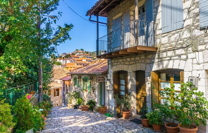
Hike the Menalon Trail [7days]
A 7-Day Journey Along the Menalon Trail – Hiking Experience
Highlights
- Multi-day hiking journey along the Menalon Trail, one of Greece’s finest long-distance routes
- Walk through a landscape of unparalleled natural beauty, with forests, gorges, rivers, and mountain scenery
- Complete an impressive 75 km certified hiking route, designed for active and nature-loving travelers
- Experience authentic Arcadian hospitality in traditional mountain settlements
- Balanced itinerary combining hiking, culture, and relaxation
Departures
All year round
Your package includes:
- Accommodation in double rooms with breakfast
- Meals : Dinner x 2 days (welcome and farewell) & Lunch box x 5 days with local homemade products
- Luggage Transfer from hotel to hotel throughout the trip
- Guide
- Hotel stay over tax payable on the spot (1,5€ – 4€ per room per day)
- Liability insurance
Itinerary
Upon arrival to Stemnitsa, settle to your hotel and in the evening get ready for an introductory meeting with a guide in the reception area of your hotel followed by a welcome dinner.
From Stemnitsa, the village of goldsmiths and headquarters for the Peloponnesians Senate in 1821, we cross the famous Lousios Gorge to get to Dimitsana.
En route, we cross old farmlands, pass through the church of the Transfiguration of Christ and admire the view of Lousios gorge before going into the paved path that leads to the Prodromos Monastery, nested right on the gorge’s walls, with a fountain in its courtyard (open every day, closes at noon). We continue to the Old Philosophou Monastery dating to 963 A.D and then to the New Philosophou Monastery founded in 1691. Afterwards, via an old mule track, we traverse to Dimitsana passing through interesting bridges, heading towards the Open Air Water-Power Museum famous for its mills which in the past generated the wealth of Dimitsana.
Distance: 12,5 km – 7,7 miles Time: 5 hours Ascent: 825 m – 2,706 ft Descent: -941 m – 3,087 ft Min. Height: 420 m – 1,377 ft Max. Height: 1,095 m – 3,592 ft
The section Dimitsana-Zigovisti ascends from the Lousios valley to the outskirts of the fir forest. The trail starts in Dimitsana and passes next to important historical buildings. Heading out from the settlement, we take the footpath that ascends gently and arrives on the first plateau, intersecting a dirt road and the church of St. Paraskevi. This location offers splendid views of the median basin of Lousios river with the settlements of Dimitsana,
Paliochori and Zatouna standing out in the wooded landscape.
The route to Zigovisti follows a succession of footpaths and dirt roads winding a plain of old fields, passing by the small monastery of St. Apostoli. The paved path heading to Zigovisti meanders through a long array of the big threshing floor. Just after passing through the Immortals Memorial, the guard of Theodore Kolokotronis, leader of the 1821 Independence War, we enter the “heart” of Zigovisti. The memory of the battles, the sacrifices and the heroes of the Greek independence war of 1821 have imbued this small yet historically significant village with a great sense of patriotic pride.
Distance: 4,2 km – 2 miles / Time: 2 hours / Ascent: 256 m – 839 ft / Descent: -61 m – 200 ft / Min. Height: 964 m – 3,162 ft / Max Height: 1,174 m / 3,851 ft
The Zigovisti – Elati section straddles the Western Menalon massif. The trail heads through a beautiful ravine, continues on a crooked dirt road and an artificially reinforced footpath to the Bourniades Spring. We then smoothly ascend to Bilali Pass, an important node of old paths that connected Radou and Stemnitsa. From Bilali Pass we ascend to the saddle between Pliovouni and Fragovouni (short cut leading to the peak of Pliovouni 1,643 meters, the highest peak of this route). Then following a steep path we enter Vlachika Plateau and follow the path to the mountain settlement of Elati.
Distance: 14,9 km – 9 miles / Time: 5 hours / Ascent: 653 m – 2,142 ft / Descent: -631 m – 2,070 ft / Min. Height: 1,109 m – 3638 ft / Max. Height: 1,550 m – 5,085 ft
The route descends from Elati to the riverbed of the Milaon River, where it meets the obvious pathway situated on the banks. Following the well waymarked trail (parts paved, parts plain path) we pass by the big water drilling rig of the Pirgaki Springs (that supplies Vytina with water) and then the stone built Makrinou Fountain. We enter for 970 meters a dirt road wending to the place name Ellinika, under the hill where the Acropolis of the antique city Methydrion was located. Hiking under the main road linking Vytina to Dimitsana we follow the nice, old mule track to Vytina. This part is the richest section of the route; moving across Milaon River in high riparian vegetation of plane trees and passing by three consecutive abandoned watermills.
Distance: 8,5 km / 5,4 miles / Time: 2,5 hours / Ascent: 234 m. – 767 ft / Descent: -375 m. – 1,230 ft / Min. Height: 918 m. – 3,011 ft / Max. Height: 1,180 m. – 3,871 ft.
After resting and provisioning, we leave Vytina to continue our route towards Nymphasia through the Old Vytina footpath that leads to Mavra Litharia, a massive limestone boulder in the riverbed of Milaon River, that the stream cut in half creating a short yet impressive gorge. We then start descending to Tzavarenas’ bridge, a solid stone bridge that secured the connection between Vytina with the western Gortynian villages. The path gains altitude in a unique rocky landscape made of flysch covered with shrubs, reaching an altitude of 880 meters and wending horizontally towards Nymphasia, a small yet lively satellite of Vytina.
Distance: 5,6 km – 3,4 miles / Time: 2 hours / Ascent: 235 m. – 770 ft / Descent: -339 m. – 1,112 ft / Min. Height: 813 m. – 2,667 ft / Max. Height: 1,041 m. – 3,415 ft.
Total daily distance: 14.1 km / 8.8 miles
We enter a pleasant oak forest, to the trailhead that heads downhill to cross the Kernitsa Bridge, from where the trail ascends to the Kernitsas Monastery, a big monastic complex nested in an impressive monolith boulder. Following a combination of footpaths and dirt roads, we cross a dense fir forest and arrive at Sfyrida Hermitage, a nice place to rest with a spring. From Sfyrida (1.000 m) we steadily ascend through the forest until the intersection for Lasta (1.250 m) from where we take a southern direction and traverse the foot of the long steep slope of Kastro. This horizontal trail continues on an old pathway. After passing the Gavros Spring, we enter the small settlement of Magouliana.
Distance: 8,9 km – 5,53 miles / Time: 3,30 hours / Ascent: 660 m / Descent: -364 m / Min. Height: 781 m – 2,562 ft / Max. Height: 1,272 m / 4,173 ft
We walk across Magouliana, through alleys and arrive to the saddle west of the village, where an intersection to Lasta is located – a point of splendid views – surrounded by stone built threshing floors. We descend toward the old sanatorium known as the Mana Sanatorium, through footpaths and narrow roads, to reach the intersection of two asphalt roads across the church of St. Pantes. The route leads down toward the valley, along a small river and moves parallel to the riverbed through small paths and alleys until the junction with another small river and a concrete bridge. The route continues to the left bank entering Kaminia, a nice small inner basin, tucked away at the foot of Valtesiniko. A good path, that was once paved, ascends to the mountain village of Valtesiniko (the village of woodcarvers).
Distance: 6,6 km – 4,1 miles / Time: 2,30 hours / Ascent: 167 m – 547 ft / Descent: -301 m – 987ft / Min. Height: 1,019 m. – 3,343 ft / Max. Height: 1,307 m – 4,288 ft
Total daily distance: 15.5 km / 9.6 miles
From Valtesiniko square, we pass by the impressive stone-built school and access the upper peripheral road of the village, stopping to gaze at the northern plains.
We gain altitude, alternating between footpath and cement road until we reach an altitude of 1,250 meters, where the path becomes clearer and runs along the ridge where the Byzantine fortress of Valtesiniko is nested.
We descend to the small country church St. Triada through open landscapes and stunning views. The next part of the route traverses an extensive fir forest through a series of artificially widened paths. After a short detour to the spring at the location Grias Lithari, we gain some altitude before going down again near Kria Vrisi fountain from where the path ascends smoothly to the saddle and asphalt road. We follow the small forest road through a wooded ridge to the location Elatakos and continue to the great Grilas meadow, with its walnut trees, threshing floors and huts. On the western edge of this zone, we see Lagkadia. Passing by the small Koubliza Spring and the impressive complex of Rapi Watermills, we enter Lagkadia (the village of the stone builders) and conclude the Menalon Trail to the war memorial.
Distance: 13,9 km – 8,07 miles / Time: 5 hours / Ascent: 596 m – 1,955 ft / Descent: -775 m – 2,542 ft / Min. Height: 937 m – 3,074 ft / Max. Height: 1,377 m – 4,517 ft
Your package excludes:
- Dinners (excluding welcome & farewell)
- Anything not mentioned above
Map
Inquiry Form
TRAVEL BLOG
Related articles
View All
![Hike the Menalon Trail [7days]](https://mazitravel.com/wp-content/uploads/2021/06/Monemvasia-destination.jpg "Hike the Menalon Trail [7days]")
Monemvasia. The peninsula of endless surprises.
At the southern tip of the Peloponnese, in the hospitable land of Laconia, there is a place of intense contrasts,...
![Hike the Menalon Trail [7days]](https://mazitravel.com/wp-content/uploads/2021/06/17503144682688320035.jpg "Hike the Menalon Trail [7days]")
Nafplio. Eternally charming, eternally romantic, eternally wonderful
Nafplio, Anapli or Napoli di Romania… Whatever name you give it, the first capital of free Greece is a unique...
![Hike the Menalon Trail [7days]](https://mazitravel.com/wp-content/uploads/2021/04/Nafplio-destination.jpg "Hike the Menalon Trail [7days]")
Argolis. In the streets of nature and history
The energy of this place vibrates you. You feel it when you walk in the archeological site of Mycenae, when...
![Hike the Menalon Trail [7days]](https://mazitravel.com/wp-content/uploads/2021/06/Athens-destinations-1300x450px.jpg "Hike the Menalon Trail [7days]")
Cultural walk in Athens
This is the most famous attraction of the Greek capital and not unjustly.
![Hike the Menalon Trail [7days]](https://mazitravel.com/wp-content/uploads/2021/06/Athens-4.jpg "Hike the Menalon Trail [7days]")
A unique cultural journey through the best museums of Athens.
In Athens, a city of great history and culture, which is constantly evolving and building the dynamic profile of a...
![City Break with food walking tour in Athens [4days]](https://mazitravel.com/wp-content/uploads/2026/01/Athens-AdobeStock_125876014-scaled-e1769512144460.jpeg "City Break with food walking tour in Athens [4days]")
Αthens : The Ultimate City Break Guide to Greece’s Timeless Capital
Ancient landmarks, vibrant neighborhoods, authentic food, and easy day trips—everything you need to experience Athens like a local Athens is...